
Humanities and their Technologies Question
TEXTO I
TEXTO II
The comparison between the satellite images indicates the occurrence of a process of
preservation of places of sentimental value.
increase in desertified areas.
Redefining national borders.
artificialization of geographic space.
Change in macroclimatic dynamics.
Resolution & Explanations
Analysis of Satellite Images of Dubai
The correct answer is option D) artificialization of geographic space.
1. A Visual Comparison between 2000 and 2020
A comparative analysis of the two satellite images reveals a drastic and unmistakable transformation in the Dubai landscape over the course of 20 years.
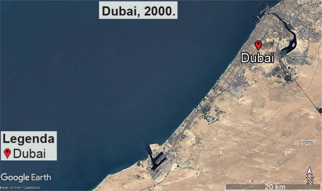
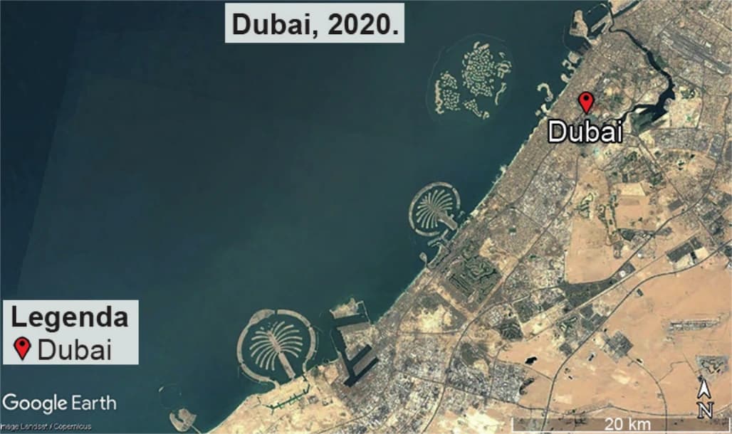
- Image from 2000 (Text I): It shows a relatively natural and straight coastline, with the city developing along it and a creek (Dubai Creek). The sea is largely free of large structures. * Image from 2020 (Text II): It shows the same area, but with the addition of gigantic engineering projects that have extended into the sea. Artificial islands such as Palm Jumeirah, Palm Jebel Ali, and The World archipelago are clearly visible.
2. The Concept of the Artificialization of Space
The process evidenced by the comparison is the artificialization of geographic spaceThis concept refers to the intense and deliberate modification of the natural environment by human action, replacing natural features with built structures.
In the case of Dubai, this process is extreme: * The natural coastline has been completely altered. * New landmasses (islands) were created where there had previously been only sea. * Geographic space, which was a product of nature, has been redesigned and reconstructed by man to serve economic and tourism purposes.
3. Evaluation of Other Alternatives
- A) Preservation of places of affection: Incorrect. The images show a radical transformation, which is the opposite of conservation. * B) Increase in desertified areas: Incorrect. The process shown is one of construction and urbanization advancing towards the sea, not desert expansion. * C) Redefining national borders: Incorrect. The creation of artificial islands expands usable territory, but does not alter a country's political boundaries with its neighbors. * E) Change in macroclimatic dynamics: Incorrect. While projects of this scale may have microclimatic (local) impacts, the images do not provide evidence of a change in large-scale (macroclimatic) climate dynamics.
4. Conclusion
The comparison between the satellite images indicates the occurrence of an intense process of artificialization of geographic spacein which the natural landscape has been profoundly altered by the construction of artificial islands and urban expansion.